| Terrain category | z0 (m) | zmin (m) | |
|---|---|---|---|
| 0 | Sea, coastal area exposed to the open sea | 0.003 | 1 |
| I | Lakes or area with negligible vegetation and without obstacles | 0.01 | 1 |
| II | Area with low vegetation such as grass and isolated obstacles (trees, buildings) with separations of at least 20 obstacle heights | 0.05 | 2 |
| III | Area with regular cover of vegetation or buildings or with isolated obstacles with separations of maximum 20 obstacle heights (such as villages, suburban terrain, permanent forest) | 0.3 | 5 |
| IV | Area in which at least 15% of the surface is covered with buildings and their average height exceeds 15m | 1.0 | 10 |
| Terrain category | z0 (m) | zmin (m) | |
|---|---|---|---|
| 0 | Sea or coastal area exposed to sea winds; lakes and water bodies covered by wind over a distance of at least 5km | 0.005 | 1 |
| II | Open field, with or without a few isolated obstacles (trees, buildings, etc.) separated from each other by more than their height x40 | 0.05 | 2 |
| IIIa | Campaign with hedges, vineyards, grove, sparsely populated | 0.20 | 5 |
| IIIb | Urban or industrial areas; dense grove; orchards | 0.5 | 9 |
| IV | Urban areas with at least 15% of the surface is covered with buildings whose average height is greater than 15m; forests | 1.0 | 15 |
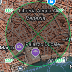
We have developped a wonderful scanner which automatically detect the terrain category for each sector of wind. If you subscribe you'l be able to use it, else you can manually set the terrain category with looking of the satellite photography. Then lisa.blue will calculate the peak velocity pressure you need to calculate your building.
On this example, you can see that Lisa.blue detected roughness IV for the north (urban areas), and roughness II for the other sectors due to the proximity with the Seine river.